Showing posts with label Oregon photo ops. Show all posts

Saturday, March 12, 2011

The Alvord Desert Road Trip


After talking about the Alvord Playa with my wife for 2 years now ad nauseam, and she insisting I should just do it, I finally made the long drive down the to the region. Located in a very remote area of Oregon about an eight-hour drive from the Portland area. I knew this time of year is one of the worst in terms of visiting the area but I don’t always get the vacation time I would like. The plan was to take my Boxer dog Scout with me in my 4Wd Montero. I finally figured out the seats in this vehicle will fold down flat including the back jump seats making an incredible bed for a tall person and that I would be totally sheltered from the elements and feel much more secure than being in a tent.

   When photographing the Playa (dry lakebed) it is preferable to go during dryer months so that the cracks that develop will be the most spectacular, and that driving out and even camping on the Playa will be possible. Well I can report that none of the above happened for me. The forecast was calling for 20% chance of snow and low temps around 27 degrees- Yaaah…Wikipedia says that this region only gets 7 inches of annual rainfall, I think 1/3 of that fell while I was there.
  
When I finally arrived there around 2:00pm after leaving my home in Clackamas at 4:30am very tired but excited to scout the area. This is one remote area I never saw another human other than one guy on a tractor meandering down Steens Mt. Rd. For being such a remote area I was totally shocked when my wife called me that afternoon, cellular service was crystal clear giving me more peace of mind should any thing happen. Driving down Steens Mt Rd towards the playa, the snow capped Steen Mountains were towering above me to my right and eventually I could see this huge light colored expanse on my left that I knew had to be the Playa that I drove all this way to see.

   I noticed that there was a lot of water in places sitting on the Playa and I was not hopeful at all about driving out on it. I found only one spot that cars could access the lakebed, I drove with caution to the edge. The water was several inches deep, I decided against trying to drive out on it at that point. After making my retreat I continued heading west for several miles until I reached the end of Steens Mt rd and the beginning of Fields-denio rd, which also marked the end of me being able to flank the playa. I noticed some faint 4WD roads that skirted the upper portion of the west end of the Playa. I thought at the very least I could catch a view of a grand vista or a nice camping spot. At this point the storms were coming in one after another rolling right over the Steen Mountains. I really had a mixed bag of weather including snow and fierce sustained winds of around 40mph gusts to 60mph, not exactly photography weather.

   As you can see from the photos I got what I was after, and a whole lot more. The view from above looking down on the Playa was spectacular; the wind, not so much. I also noticed that I had a flat tire on my brand new Les Schwabbies presumably from one of the sharp rocks, it slit the rubber between the treads. During my research of the area I had read accounts of the people getting numerous flats out here and sure enough I was also a victim. Now I know why people buy off-road jacks, they are much easier to use than crawling under a vehicle to prop up a 11/2 ton hydraulic car jack that only raise the tire about 5 inches. It took about one hour for me to change that tire and boy was I glad I brought a shovel. I just could not get that spare on without some excavation work.


   I was determined to set foot on the Playa and try some photography after driving all that way, Scout and I headed down a very steep hillside that would allow some access to what looked like a dry section of the lakebed. Distances are very tricky out there with no discernable landmarks. It took twice as long as I would have thought to reach the playa. The photography gods smiled on us for a brief time allowing for a little photography that you can see here. I was also pretty impressed with the cracks, if only I could keep scout from running in circles in front of my comps with his muddy paws and ruining my shots.

   After returning up the hill and to the car it was nearly 4:30pm and I decided to wait and see what kind of sunset might transpire in terms of a lightshow or lack thereof. I waited patiently and watched the storms continue to come, finally the weather broke and I was able to set up the tripod and make an attempt at an image. Cloud cover mostly obscured the sun and the sunset was, for the most part a bust as you can see in this photo.


   Camping in this area was totally out of the question the wind and rain was so intense it ripped the shovel off of my luggage rack that I had attached with bungees. I knew I wanted to go home via an alternate route that would take me into Nevada and then onto Lakeview Oregon via Hwy 140, then through K-falls and Medford and up I-5 to home.  I got gas at a place called Denio Station for about $5.00/ gallon I'm not really sure what I paid I just know I told the guy $40.00/worth. At this point in the evening it was clear and cold, I was exhausted and needed to find an area to camp for the night. I drove about twenty more miles and found a very small rest area where I promptly pulled over. I ripped every thing out of the vehicle so I could make the sleeping configurations with the seats, then blew up the therma-rest and pulled out the 0-dgree bag. We spent 11 hours in the car getting up several times two warm up the car. It got very cold that night and it snowed on us as well. The photo you see below is Hwy 140 after the snowstorm. Needless to say that the 100 miles to Lakeview were a little hairy.


 It took about five hours to reach Medford from the Alvord Desert. All in all I drove 1100 miles in about 38 hours. If I ever decided to come back to this area again I would prefer to go in the late summer, maybe September. I will also bring two spares, it is unnerving to have already used your spare and not have a backup in such a remote area.

   If you plan on coming to the Alvord Desert the best and shortest way from Portland is to come through bend then onto Burns. Take Steens Hwy out of burns #78 south; turn right on to Steens Mountain Road it is well marked. This road will take you to the Alvord desert. Another option is to go south out of Burns on Hwy #205 towards the town of Frenchglen. This road eventually turns into Catlow Valley Rd. It takes just over two hours from Burns with this option.  Enjoy.. 


Note* For higher quality images of this area go here.

Sunday, October 3, 2010

Billy Chinook Falls


We recently took a 400-mile road trip this first weekend in October. Mainly I was in search of fall color Near Willamette Pass and also was looking forward to some Aspens near Black Butte. Neither of those images came together for various reasons. We did however manage a nice lunch in Sisters and made a large loop through Redmond and back over Mount Hood. Took a short detour through Lake Billy Chinook in hopes of finding Billy Chinook Falls and any other interesting comps of the reservoir. This is what I came away with. If you ever want to drive through the area you may want to know that continuing on towards Pelton Dam and lake Simtustus makes for a nice scenic drive and really doesn’t ad much more mileage as you will T-bone right into Hwy 26 just South of Warm Springs.

Sunday, September 5, 2010

Sahalie Falls Willamette National Forest

Sahalie Falls Mt Hood
Sahalie Falls
Koosah Falls
During recent months I have noticed an increased number of folks using the search terms Sahalie Falls or Sahalie Falls Mt Hood. I then realized that there might be a little confusion on these falls. Yes there are two separate falls named Sahalie in Oregon the lesser-known one is located on Mt Hood, which I have already Blogged about in the past. The larger and much better know Sahalie Falls is located just off of Hwy #126 in the Willamette National Forest near Clear Lake. If you are in the area I highly recommend a trip to these falls which have the added bonus of seeing the rather spectacular Koosah Falls a mere ¼ mile away. You may also wish to make a short side trip by car to visit Proxy falls Located on the Old McKenzie River Highway #242 about 9 miles from Highway #126.
Proxy Falls
 Note: as of June 2010 when I was there Highway # 242 is blocked by a snow-gate at the 11 mile mark. You can photograph the falls but will have to double back if proceeding on to Bend or any points East..  


Sunday, June 20, 2010

Salt Creek Falls, One To Remember

Salt Creek Falls

The most visited natural attraction along Oregon’s Hwy# 58 better known Willamette 
Highway No. 18 is Salt Creek Falls.
The Parking area and restrooms with flushable toilets are located 60 miles East of Springfield or 38 miles NW of Chemult Oregon. When you arrive you will have access to a kiosk that shows the history of the area as well as maps and trail descriptions. The falls themselves are breathtaking on two fronts the sheer vastness of the canyon with the creek below and of course the huge volume of water that flows. These falls have the highest and most consistent volumes of water in any of the Southern Oregon falls. The forest service claims this is the second highest falls in all of Oregon; Watson Falls come in a close third.

Salt Creek
I found these falls a little tough to photograph especially when there is strong sunlight causing exposure problems. The second thing that makes photography tough is that the entire upper viewing area is protected by a high guardrail that runs the rights flank of the falls. There is a small lower viewing platform that allows for a frontal shot. I had to go way off trail to get the vantage point you see here. The spray is very powerful and carries downstream for a few hundred yards. I took a dozen shots and all the while had to keep wiping my filters off, I really only came away with one semi clean shot.

If you feel the need for more exercise there are two more falls here that can be accessed by foot, Fall Creek Falls and Diamond Creek falls. If you don’t care about the exercise than I might skip the 6 miles of hiking, as these falls will be a bit of a disappointment. 

Tumalo Falls In Depth


Tumalo Falls
Bend Oregon is truly a magic place but especially so if you happen to be an avid landscape photographer. First off the central Oregon locale is a great launching point for many nearby shooting locations and the town is clean, well kept, and has every thing one would need in a small town. For me being partial to waterfalls the crown jewel in the area is Tumalo Falls. A mere 10 miles almost due west of the city these falls are a must see. Tumalo falls is not a state park so please do not confuse this area with Tumalo Sate Park located off of Highway #20 also right outside of Bend. Tumalo Falls and the creek that feeds it are part of the Bend watershed but the public is welcome. There is a medium sized parking area complete with toilets when you arrive. There are two viewing areas for the falls including a perch that overlooks the top. The area seems to be popular for mountain bikers and cross-country skiers in the winter months. Besides hiking to the top of the falls you can continue on another 4 miles to Happy Valley.


The perspectives of the falls that you see here required me to go off trail a bit trying to tread lightly respecting the ecosystem.

Tumalo Falls


For a bit of history on the area you will learn that there was a very destructive fire that occurred in 1979 that destroyed the area including Tumalo Creek. Only recently in 2004 there was a concerted effort to re-build the area by excavating and reshaping the natural flow of the creek as well as hand planting 700,000 trees. You will notice how young the forest is surrounding the falls and it really makes for a unique landscape.


Nearby China Hat
Getting there: From 3rd St. in Bend (ie. downtown Bend), turn west on Franklin Ave. Drive 1.2 miles (past Drake Park) to Galveston Ave. (also signed as Tumalo Rd). Turn right and drive 10.8 miles along Galveston (which turns into Skyliners Rd.). Immediately after crossing Tumalo Creek, turn left onto Road 4603. Drive 2.5 miles to the Tumalo Falls parking area. The road 4603 is closed in the winter so hiking in is the only way to reach the falls.


Directions are courtesy Leon Turnbull of waterfallswest.com Thanks Leon...

Central Oregon Points Of Interest

Ponderosa Forest
Laurie and I just got back from another 900-mile road trip taking us through Central Oregon and Christmas valley. I came away with many great images including Fort Rock and several noteworthy waterfalls. I will break down the trip with separate blog postings on specific areas of interest. The next few blogs will be related to this recent trip so stay tuned. I had specific areas in mind and mapped them out before leaving and was able to get to all of them except for “ Crack-In-the-Ground “ and the” Lost Forest “. I hope some of the information you get here will be a help to you on you’re travels.

Sunday, May 9, 2010

Golden And Silver Falls Park Profiled

Silver Falls
If you’re looking for a couple of unique waterfalls off the beaten path then I have the answer. Golden And Silver Falls State Park contains two stunning waterfalls with drops of nearly 200 feet respectively. Each of these falls can be photographed after only a very short walk from the parking area. Total hiking trail length in the park is about three miles, however that’s only if you wish to take the upper trail to Golden Falls and back. The lower and shorter trail will yield some great compositions of the falls.

I guess the only downside to this park is the is the journey there, often times traveling over very winding and narrow county roads. We encountered very few cars but did have a couple of loaded log trucks come at us on sharp turns. There are many spots on this road near the end that won’t allow two cars to pass, so be careful.

Golden Falls


Getting There: Heading South on US 101 go completely through the town of Coos Bay. When you see a 7-Eleven on the left take a left turn at the second light. This exit will say Coos River- Allegany. Once you take the exit you will immediately cross a bridge over the Coos River. From this spot set you’re trip odometer as it is exactly 24 miles to the park from here. You will pass through the town of Allegany at the 14-mile mark. Just continue on for 10 additional miles, the last 4 – 6 miles are gravel but it’s not a bad ride as gravel roads go. When you reach the park you will find a rustic outhouse and hiking instructions to each of the falls.

Good Luck..   Shawn

Wednesday, May 5, 2010

Abiqua Falls Complete Review And Directions

Abiqua Falls


For the longest time I have heard tale of this elusive waterfall called Abiqua Falls. Iv’e seen it profiled on a couple of blog’s and seen many photos of it on Flicker Ect..
I recently made the trip over to Scott’s Mills Oregon and finally got to photograph these falls. I have yet to see anyone give a very detailed account of what to expect and give precise directions.
Ok here is the skinny on what I experienced. Getting there: Take Hwy #213 or the Cascade Highway to the town of Markum. When you see the Markum Inn you will turn off onto S Nowlens Bridge rd, it only go East. Take Nowlens Bridge rd approximately 2 miles until you T-Bone into Crooked Finger Rd NE, turn left. At this point reset you’re trip odometer. You will now travel exactly 9.5 miles until the road ends or at least the pavement ends. Reset you’re trip odometer once again and travel exactly 1.4 miles. Turn right onto Cf300, a very illegible white sign on a tree on you’re right will denote this road as well. You will basically travel as far down this road until you cant go any further. You will pass several clear-cut areas and intersections; always go straight and downhill through these. The road will deteriorate as you get further down and some say passenger cars can make it. I would strongly discourage any thing other than a high clearance vehicle with 4wheel drive. When you come to an old yellow locked gate you have reached you’re destination by vehicle . Park in a small turnout just prior to the gate; there is maybe room for three vehicles here.
Abiqua Vertical
Don’t do what I did and travel by foot beyond the gate and down the road, I added about 4 miles of unnecessary hiking to my trip. To find the trail, I mean goat path to the falls simply walk up river or the direction you came for approximately 300 ft. You will see a fairly heavily used footpath heading down towards the river. You will also see two large white No-Trespassing signs that warn against hunting and firearms ect.. posted on trees at the beginning of the trail.
Did I mention goat trail? The path down to the river is steep and fairly treacherous. There are lots of possibilities to turn an ankle or slip and maybe damage yourself or equipment Be Careful.
Once you reach the river you will have dropped maybe 1000 ft or so, head upstream the best you can until you reach the falls. It’s only about a 5-7 min walk once you have reached the river.
The falls are beautiful and well worth the effort; however I was struck at the size of the area I was expecting it to be much larger. A wide angle lens is a must, I shot with a 16-45mm on an APS C censor and could barely encompass the whole scene. Those of you shooting full frame or one of the 10-20mm will have no problem. Also keep in mind the spray factor; I was constantly wiping my lens or filters off. If you come in late summer then you’re options open up quite a bit as you can wade across to the other side or stand in the stream to avoid the composition obstacles I faced.

Happy Adventures Shawn..

Sunday, February 7, 2010

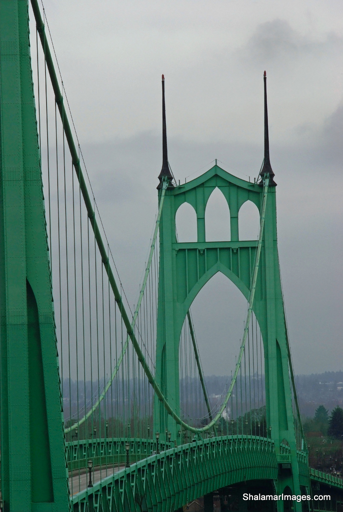
Photographing The St Johns Bridge


St Johns Bridge
Many Oregon photographers enjoy shooting our local bridges, and you will find no finer bridge than the St Johns Bridge in North Portland. This bridge has frankly been shot to death but having said that there’s nothing like having your own files and also to enjoy the experience first hand. I have seen this bridge shot from so many perspectives over the years but one caught my eye especially from a great local photographer named Jesse Estes. His night shot is truly spectacular. This renewed my interest in this bridge and wondered how he got that particular vantage point. Well it turns out it’s really quite simple to find, although I made it extra tough on myself by taking the long way up the ravine and cross country with dog in tow.
If you are heading West on Hwy #30 and take the St Johns bridge exit to climb the steep road to the bridge entrance you will see a turnout about ¾ of the way up on you’re left. Park here and proceed West on foot approximately 1000 ft until you come to a series of steep concrete steps that lead to a landing with a hand rail. Continue west a very short distance until you come to a wood footbridge that overlooks the bridge and that is relatively free from blocking trees. This will be your tripod spot.

Architectural Lines
After shooting here and arriving back at you’re car feel free to cross the Columbia River on said bridge and proceed to Cathedral City Park located at the foot of the bridge on the North side.

You will find many compositions in this area as well.

Sunday, January 24, 2010

Cape kiwanda Photography


Haystack Rock Sunset
All I can say is wow! What a photographers dream. I’m talking about The Oregon coastal hot spot of Cape Kiwanda. I have seen so many wonderful dramatic images from this area but personally have never explored the cape before yesterday. Laurie and I drove up to catch the sunset and get the dog out for some exercise. As I started climbing the cape I instantly knew I was in for a real treat photographically speaking.

The compositions are endless the weather is ever changing and the wave action can’t be beat. The reddish sandstone cliffs are beautiful as well.

To top things off the Pelican Brewery is only a stones throw from the parking area. Great food and even better selection local Micro Brew. They serve breakfast lunch and dinner. I highly recommend the restaurant.

Now back to the cape and the photography. If you’re coming from out of town you can stay at the Inn at Cape Kiwanda . This will allow you to chase the sweet light morning and evening. One day is not enough in my opinion to truly capitalize on the possibilities here.
Unique Formations
There are restricted areas that are somewhat cordoned off but most people disregard the warnings and proceed anyway. Be careful near the cliffs but especially watch out for sneaker waves if you’re shooting near the ocean on the north side of the cape.

Very near to the cape is Bob Straub State Park where you will have distant views of Haystack Rock and lots of grasses that always make a great foreground element.


Getting there: From Lincoln City, follow U.S. 101 North through the town of Neskowin and follow the signs to Cape kiwanda. From the Portland area take Hwy 22 through Salem then tie into Hwy #18 west. Take a right turn in the town of valley junction onto Hwy #22 Tillamook/ Hebo and follow this winding narrow road until you see a left turn off for Pacific City, you will now be on Hwy #130. Follow this straight into Pacific City..

Just a quick side note about Haystack Rock; yes it’s true there is more than one Monolith off of the Oregon coast with that name, in fact there are three. You will find one haystack rock in the town of Cannon Beach another in Pacific City and the final one is located outside of Bandon on the Southern Oregon Coast.

Saturday, September 12, 2009

Eastern Oregon,Hells Canyon and the Painted Hills


Laurie and I just got back from an Eastern Oregon road trip that encompassed the entire northeast region of the state. It’s hard to believe we traveled over 900 miles and never crossed state lines and really only scratched the surface in terms of exploring Oregon in it’s entirety.
The Painted Hills

The trips conception was certainly based on photographic pursuits as well as seeing areas of Oregon that were new to us. On the short list were of course the Painted hills, Hells Canyon, and the Wallawa Mountains to include Wallawa Lake.


We traveled over Mt Hood through Maupin down into Shaniko, Fossil and finally reached the town of Clarno. The first of three visitor areas that make up the John Day Fossil beds National Monument start in Clarno. There is little to see here except for some ancient rock formations that were formed 55 million years ago
. Just three miles east of Mitchell Oregon we found the Painted Hills Unit. These are spectacular and quite stunning to see first hand. A photographer’s paradises indeed as you catch the first glimpse of color in the hills. However it’s not just the color that makes this place so special; but also the perceived texture of the formations that give it that otherworldly feel. The formations look like velvet but are actually made up of hard clay, Siltstone and Shale.
Painted Patterns

Approximately 1-hour east near John day are the Sheep Rock Unit and more fossil beds. This area was a bit of a disappointment. We were to late to enter the Thomas Condon Paleontology Center, which houses all of the regions Fossil collections. Also the formations were jagged and a bluish green in color. If we had more time I would have liked to take in a couple of the nearby hiking options to explore further.


We spent the first night at the Best Western in John Day knowing full well we had a huge day ahead of us in the morning. After several hours of wandering through vast uninhabited regions of the northeast we stopped in Baker City to refuel ourselves as well as the car. The next objective was to head into the Hells Canyon region of Oregon to catch a glimpse of the Mighty Snake River. It turns out that the wild Snake River is considerably north and down stream of the Hells Canyon Dam. We never did see any beautiful scenery of the Snake River and decided to cut our losses and take the only road over towards Joseph and Wallowa Lake. Yes it is a 64-mile wild ride of twists and turns that takes you past the Hells Canyon Overlook. It is quite a vista and deep gorge and yet the Snake remains elusive even here.

Painted Detail
Hells Canyon Overlook
When we finally reached Joseph we were somewhat weary travelers at this point and decided to book a room only minutes from the lake. Stayed in a old but quaint motel called the Indian Lodge Motel. New mattresses and fire hydrant like water pressure in the showers were a couple of nice attributes. The town of Joseph is very nice and is bolstered by a huge art community that has donated many works to the city, which are displayed along the streets. Apparently there are three bronze foundries in town as well. The town takes on a wonderful vacation feel in the evening hours as many of the business are creatively lit which ads to the warmth of the town. We took an evening stroll after enjoying a fireside outdoor meal at the Embers Brewhouse.
Wallowa Lake At Dawn

I awoke early, pre dawn in fact to photograph Wallowa Lake; however that magic moment never materialized and I was disappointed with all of the images. The sweet light doesn’t always happen especially on a cloudless Eastern Oregon morning.

Anthony Lakes

The next day took us through Tollgate Oregon and up and over the Blue Mountains where we visited the Anthony Lakes area.
We then came through Pendleton and linked up with I-84. It's a 200-mile trip through the Gorge to home so we stopped off in the Dalles for a Mexican dinner at El Mirador.
Great trip as always and I thank Laurie for all the safe driving and companionship.

Sunday, August 2, 2009

Oneonta Gorge Adventure Awaits You !!


Oneonta Gorge


Have you wanted to go on a really cool little adventure? Well I have the answer and it may come as a surprise how relatively easy it is and within such a close proximity to the Portland area. I'm talking about Oneonta Gorge located just east of Multnomah Falls on the Historic Columbia River Highway.

The adventure part comes in when you're hiking trail is a stream and you must negotiate a huge log jam; other than that it's a piece of cake in terms of outdoor photography outings. You see over the course of a couple of extreme winters and subsequent flooding huge amount of deadfall and lumber have piled up in the mouth of Oneonta Gorge. Once the logs have been crossed it's an extremely easy stroll through the creek less than ½ mile to the Lower Oneonta Gorge waterfall.
Oneonta's Narrow Gorge

The water this time of year was extremely comfortable and the deepest pool went up to my waist. I'm 6' 3" and so I may not recommend this hike for smaller children. I chose to wear my Hodgman Wading boots with the felt sole, worked like a charm. Get there early to avoid crowds if you can. I arrived at 8 am and had the Gorge to myself, any earlier and lack of light would be an issue. You also may be wondering if there are dry spots to set you're gear down and set up shot and yes there are plenty of dry areas that are exposed this time of year.
Oneonta Falls

Getting There: Coming from Portland take the Bridal Veil Exit off of I-84 then proceed East passing Multonmah falls by approximately 1 mile. The parking area is well marked on the right side of the road and is denoted by a large sign reading Oneonta Gorge as well as a large wood pedestrian tunnel.

Happy adventures, Shawn…

Sunday, July 26, 2009

Heceta Head Lighthouse And The Legend Of The Lady In Grey


Most of the Family and I just got back from a mini trip to the central Oregon Coast. Florence to be exact where we rode Quads at
Winchester Bay in the heart of dune country just south of Reedsport Oregon. I highly recommend this activity. If you are a first timer and want to get an idea of the sport there are many rental options in the area. I recommend Dune Country ATV rentals.

One of the main attractions of the trips for me was to visit and photograph the nearby lighthouses. The Umpqua lighthouse is located virtually next door to the previously mentioned Dune Country and in the heart of Discovery Bay. The Lighthouse itself sits amongst the Coastguard barracks and housing making photography very uninspiring. The lighthouse is well kept and has been freshly painted. The only good vantage point for photography is from out in the dunes area looking back at the lighthouse. You may be able to eliminate most of the distracting elements from this vantage point.
Heceta Head Lighthouse

Next we set off approximately 1-hour north on the #101 to visit the Heceta Head Lighthouse. Just prior to reaching the parking area you will be rewarded with a spectacular view of the lighthouse from a roadside viewpoint. Once inside the parking area there is a self-pay area that you will need to purchase a $3.00 parking permit from. There are nice well maintained trails that take you right up to the lighthouse where guided tours are available for those that are inclined to walk inside and hear a little history about the area and the adjacent
haunted lightkeepers house. The legend of the Gray Lady.
As far as photography goes, there are many compositions to choose from and as a matter of fact a trail will lead you directly behind the lighthouse so you may get this vantage point.

Ideally the best scenario is to sit patiently behind the lighthouse looking west and wait for that incredible sunset and capturing the glow of the Fresnel lens as it makes it’s revolutions. This would require some planning and walking out in the dark of night.

I wish to make a trip back to do just that and in addition would spend several hours at the
Cape Perpetua Scenic Area. Along with “ Cooks Chasm “ and “ Spouting Horn “ the park offers so much photographically in terms of big waves and lava formations. It should be on the short list of every landscape photographer.

Heceta Coastline with Cape Creek Bridge

Happy shooting. Shawn….

Saturday, July 18, 2009

Top Portland Photo Outings


I am profiling great photographic trips based out of the Portland area that have an approximate two hour driving radius. They are in no particular order.


1. Waterfalls of the Columbia River Gorge


On any given day you can bag several waterfalls in any season of the year. Many waterfalls are located within short mileage of the trailheads. I suggest making a detailed itinerary of you’re day and be conservative with you’re expectations. Remember that there is always tomorrow and you may get fatigued much sooner than it may look on paper. I research and then make list complete within good directions before leaving. I then pack the photo bag with only what will be needed for that day. As a resource I use
The Northwest Waterfall Survey


2. Rowena Plateau


If you are going for wild flowers late April to mid May is you’re best bet. The Rowena Plateau is Located at exit #76 off of I-84 the exit sates Rowena/Mosier. There are grand vistas that overlook the Gorge below as well as very unique and photogenic
roads. Other options for this outing include photographing wind surfers out of the Hood River area. You may also cross the Hood River Bridge or the Bridge Of The Gods (toll Bridge) out of Cascade Locks and Visit the Columbia Hills and Then Beacon Rock on the Washington side.


3. Clackamas Whitewater Events


Grab you’re long glass and practice honing various sport photography techniques. Any event on the upper Clackamas or nearby river will do; however the annual
Clackamas Whitewater Festival is the best. For a sample of what you may find click
here. The festivals website.


4. Wild Horses On The Warm Spring Reservation


This should rank as one of the top outings and is really enjoyable. There are many wild horses on the Reservation but you will probably want to find the large herd. It may be difficult to locate the herd at first but if you are lucky they will be located near the north Kah-Nee-Ta entrance. Mt Hood and Mt Jefferson serve as incredible backdrops for horse photography in this location of the reservation. You can go any time of year and in fact snow on the ground really adds a great element. The horses are quite skiddish and I would recommend working with a partner to really get great shots.
Here are a few shots I took from some past trips.


5. Crystal Springs Rhododendron Gardens


Many of you local Oregonians living near Portland may be unaware of the beautiful park that we have right in our midst.
I'm talking about the Crystal Springs Rhododendron Gardens located across from Reed College and adjacent to East Moreland Golf course. For you photographers there are many prospects here. This is a romantic park with many trails and water features. Free admission awaits those that can visit any Tuesday or Wednesday. For more information here is the website.


6. The City of Roses


What a magnificent city we have in terms of photography; from many unique bridges to uncompromising architecture, a mountain backdrop city fountains and of course the Willamette river. Morning is the ideal time from my perspective as the water is often calm and the sun illuminates the city from the east. Once the sweet light has faded you are now ready to get up close and personal with fountains, people, architecture and art.


7. The Annual Tigard Balloon Festival


Launched out of Cook Park In Tigard this annual event draws large crowds. The great thing is that you can get really close to the action, which makes up for the dismal landscape and venue. I suggest a fast 2.8 lens as the first launch takes place in the pre dawn hours. More info can be found here.


8. Covered Bridge Tour Of Cottage Grove


Truth be told I personally wasn’t that inspired the one and only time I took this tour; however I have seen some magnificent photography out of this area and think it deserves a spot on the list. Fall is the ideal time to visit these historic and preserved covered bridges from Oregon’s past. For more info on details about this tour click here.

Wednesday, June 17, 2009

Gorge Hikers Beware !!

 
Just got back from another Waterfall Photography trip with with two of my sons today.The goal was not overly ambitious as seems not to be the norm whenever I go out. We hiked up to Ponytail falls from the Horsetail Falls trail head. I spent 20 min or so photographing and then we proceeded another 1.3 miles to photograph Triple Falls. For those of you planning a trip in the are be forewarned that the bridge just beyond Triple Falls on trail #424 that crosses Oneonta Gorge was damaged and has been removed. The Oneonta Gorge is impassable at this time. This makes a loop trip impossible. As a matter of fact you cannot access Triple falls or beyond to Larch mountain from The Oneonta Gorge Trail #424 at this time. The bridge is budgeted and slated to be replaced this year 2009. Another note able about the area is the fact that there is a sizeable log jam at the entrance to Oneonta Gorge. For those of you including myself this only means that there will be a Little more adventure involved when we decide to don our Tevas and wade up the slot canyon and through the water. for any reason including magnificent photo ops. I hope this helps.. Happy Hiking, Shawn.
Posted by Picasa

Sunday, May 24, 2009

So You Want To Hike Opal Creek Huh !

Posted by Picasa
Opal Creek located in the Elkhorn Valley recreation area is one of the most beautiful river hikes you will ever experience. Opal creek feeds the Little North Santiam River that is equally clear and pristine however opal creeks color is unmatched and truly lives up to its namesake. I suppose you could use emerald to describe the watercolor as well.


If you want to experience the hike for yourself here is a link for great driving directions. I guess the only downside of this hike is the 2.2-mile hike down a gravel-logging road to reach the actual trailhead. This hike is suitable for small children and is classified as easy with an elevation gain of only 200 feet. I would caution parents to be very watchful on a couple of bridge crossings and on section of trail where there is no rail to protect from a substantial fall.


The area attracts extreme kayakers as well as backpackers. There are several wonderful campsites along the river although campfires a prohibited. If you have come for merely a day hike you may opt for the 7.5 mile loop that will take you through Merten mill and Jawbone Flats an old gold and iron mill that operated from 1929-1932. This loop will also take you to Opal Pool, another attraction that will take you’re breath away. If your feeling energetic you can continue past Opal Pool another 1.5 miles which will take you past Cedar flats (ancient Red Cedars) and several small water features. Happy Hiking !!

Sunday, May 3, 2009

Crystal Springs Rhododendron Gardens


Many of you local Oregonians living near Portland may be unaware of the beautiful park that we have right in our midst.
I'm talking about the Crystal Springs Rhododendron Gardens located across from Reed College and adjacent to East Moreland Golf course. For you photographers there are many prospects here. This is a romantic park with many trails and water features. Free admission awaits those that can visit any Tuesday or Wednesday. For more information here is the
website
Posted by Picasa

Sunday, February 22, 2009

Oregon Photo Ops


I have found another opportunity for Photo Ops on the Upper Clackamas River photographing the onslaught of rafters and whitewater kayakers that come down. This is a great opportunity to get great action shots from the bank and to practice and hone you’re skills for action sports. If you check various sites like the Upper Clackamas Whitewater Festival They have an annual whitewater event that brings many photographers out.
All Content © ShalamarImages.com
and Shawn Martin
Copyrights vigorously enforced