Tuesday, May 11, 2010
Sunday, May 9, 2010
Golden And Silver Falls Park Profiled
 |
| Silver Falls |
I guess the only downside to this park is the is the journey there, often times traveling over very winding and narrow county roads. We encountered very few cars but did have a couple of loaded log trucks come at us on sharp turns. There are many spots on this road near the end that won’t allow two cars to pass, so be careful.
 |
| Golden Falls |
Getting There: Heading South on US 101 go completely through the town of Coos Bay. When you see a 7-Eleven on the left take a left turn at the second light. This exit will say Coos River- Allegany. Once you take the exit you will immediately cross a bridge over the Coos River. From this spot set you’re trip odometer as it is exactly 24 miles to the park from here. You will pass through the town of Allegany at the 14-mile mark. Just continue on for 10 additional miles, the last 4 – 6 miles are gravel but it’s not a bad ride as gravel roads go. When you reach the park you will find a rustic outhouse and hiking instructions to each of the falls.
Good Luck.. Shawn
Wednesday, May 5, 2010
Abiqua Falls Complete Review And Directions
 |
| Abiqua Falls |
For the longest time I have heard tale of this elusive waterfall called Abiqua Falls. Iv’e seen it profiled on a couple of blog’s and seen many photos of it on Flicker Ect..
I recently made the trip over to Scott’s Mills Oregon and finally got to photograph these falls. I have yet to see anyone give a very detailed account of what to expect and give precise directions.
Ok here is the skinny on what I experienced. Getting there: Take Hwy #213 or the Cascade Highway to the town of Markum. When you see the Markum Inn you will turn off onto S Nowlens Bridge rd, it only go East. Take Nowlens Bridge rd approximately 2 miles until you T-Bone into Crooked Finger Rd NE, turn left. At this point reset you’re trip odometer. You will now travel exactly 9.5 miles until the road ends or at least the pavement ends. Reset you’re trip odometer once again and travel exactly 1.4 miles. Turn right onto Cf300, a very illegible white sign on a tree on you’re right will denote this road as well. You will basically travel as far down this road until you cant go any further. You will pass several clear-cut areas and intersections; always go straight and downhill through these. The road will deteriorate as you get further down and some say passenger cars can make it. I would strongly discourage any thing other than a high clearance vehicle with 4wheel drive. When you come to an old yellow locked gate you have reached you’re destination by vehicle . Park in a small turnout just prior to the gate; there is maybe room for three vehicles here.
 |
| Abiqua Vertical |
Did I mention goat trail? The path down to the river is steep and fairly treacherous. There are lots of possibilities to turn an ankle or slip and maybe damage yourself or equipment Be Careful.
Once you reach the river you will have dropped maybe 1000 ft or so, head upstream the best you can until you reach the falls. It’s only about a 5-7 min walk once you have reached the river.
The falls are beautiful and well worth the effort; however I was struck at the size of the area I was expecting it to be much larger. A wide angle lens is a must, I shot with a 16-45mm on an APS C censor and could barely encompass the whole scene. Those of you shooting full frame or one of the 10-20mm will have no problem. Also keep in mind the spray factor; I was constantly wiping my lens or filters off. If you come in late summer then you’re options open up quite a bit as you can wade across to the other side or stand in the stream to avoid the composition obstacles I faced.
Happy Adventures Shawn..
Sunday, April 25, 2010
Photogaphy Paintings
A technique I’ve been having fun with lately is that of impressionistic photography or digital painting. I first heard about this technique in a recent article in Outdoor Photographer. I really loved the painterly fell to the images, but it was more than that; something unusual and very different than a painting, painting with light
 I recently got the chance to try out this method on a large tree farm near Umatilla Oregon. The trick for making these images work is the exact amount of blur and that can really only be achieved by trial and error. There is no exact blueprint for every situation.

The ideal equipment for this upward panning technique is to have a tilt and pan tripod head, giving you more control over lateral movement. I only have a ball head and have done the best I could. Typically here is the rundown: 1. Find a subject with vertical lines preferably 2. Mount camera on tripod and set a 2 second timer. 3. Using a neutral density filter and a relatively small aperture to achieve an approximate 2-3 second exposure 4. Depress the shutter button and anticipate when the shutter will open, then begin panning skyward during the entire exposure. 5. Check the LCD for the results and repeat if necessary.
I hope you give it a try it’s a lot of fun..
Wednesday, April 14, 2010
Palouse Falls Adventure Awaits
 |
| Palouse Falls Sunset |
Palouse Falls can be seen immediately as you drive into the campground ; in fact you can hear the cascading water while in your tent along with other sounds like the coyotes howling in the distance. You will find unique wildlife in the area such as: Coyote, Mule Deer, Raptors,Rattlesnakes, Jack Rabbits and hundreds of Marmots to name a few.
Palouse Falls are quite breathtaking and very photogenic as well. You may not always be blessed with beautiful clouds but there are many wonderful compositions as well as trails that will take you most of the way around the canyon. Finding a unique perspective is always a challenge; most photographers choose to incorporate the falls and the down stream portion of Palouse River in their shots.
 |
| Marmot |
Overall it was a memorable trip although I would love to visit again right before the fall harvest. Maybe I’ll have that Pano Head by that time.
Until next post, hoping you all find the sweet light.
Shawn..
Recommended Book
Wednesday, March 24, 2010
Snoqualmie Falls And The Salish Lodge Review
 |
| Salish Lodge With Snoqualmie Falls |
If you have come to photograph theses falls, compositions are surprisingly pretty limited. Most of the shots you see are taken from the upper viewing platform or anywhere along the upper guardrail. There is a snack shop / souvenir store with restrooms at this location as well. Additionally if you feel like a somewhat steep hike down to the base and through the Puget Sound Power Plant you will find more up close and personal compositions. The conditions you find below are directly related to the amount of flow the power plant is releasing. At times you will find a full lake with very little foreground element and other times you will see a boulder-strewn landscape. Spray from the falls is always an issue. At times the spray is so powerful you can feel it from the upper viewing decks.
I highly recommend the lodge for a short stay and also recommend the photography. When you first arrive at Salish lodge you will find the valet staff promptly greets you. The mandatory valet parking is a little excessive for my taste considering they are only parking you’re car a mere 20 or 30 ft away. I guess some folks really consider it a luxury however I find it a bit of a nuisance. If you want to get something out of your own car you must first hand in the valet tag to get you’re keys and then hand them back when you are finished. Then there are the etiquette rules about tipping. I kind of felt like that was a little Vegas-like.
The lodge has a wonderful Day Spa that is complimentary for all guests. Complete with mineral soaking pool, large hot tub with water feature, steam and sauna rooms as well. The staff doesn’t allow anything above a whisper inside the spa area and the hot lemon tea is a nice touch as well. For you gamblers the Snoqualmie Casino is very impressive Picturesque and clean and only 5 min from the lodge. The Falls are located just off I-90 about ½ hour East of Seattle. Situated between the towns of North Bend and Fall City. If you are in the area for the dinner hour I can highly recommend the Fall City Roadhouse, Located in Fall City about 5 min from the Lodge on Hwy 202; the food is fantastic..
Wednesday, March 3, 2010
Noise Reduction Software Reviews
As photographers we strive for a certain identifiable style that we can call our own and to that end we look for the tools that will help us achieve the best results in the digital darkroom. One of the biggest issues we face in postproduction is that of digital noise which is inherent to today’s image sensors and there limitations.
Most image editing software come with there own noise reduction solutions some better than others. I recently purchased the plug-in version of Imagenomic’s Noisware software. I am very pleased to say the least. The program is fully customizable but also has presets for Landscapes, portraiture ect.. The beautiful thing is that Imagenomic make a
work as a 16 or 32 bit T.I.F.F.
Don’t’ get me wrong I do believe that there are other fine noise reduction software out there like: Noise Ninja, NIK Dfine 2.0, Neat Image, Alien Skin Image Doctor, Fred Miranda ISOx Pro, and the list goes on and on. For me I truly believe this is a quality product that works. After all balancing the noise and sharpness while retaining color saturation is a real balancing act that requires the correct algorithms. Here is a comparison between Noisware and Noise Ninja.For more comparisons of many other software go here. Imagenomic make other great products as well and even offer a bundle that includes: Portraiture, Noisware and Real Grain.
Sunday, February 7, 2010
Photographing The St Johns Bridge
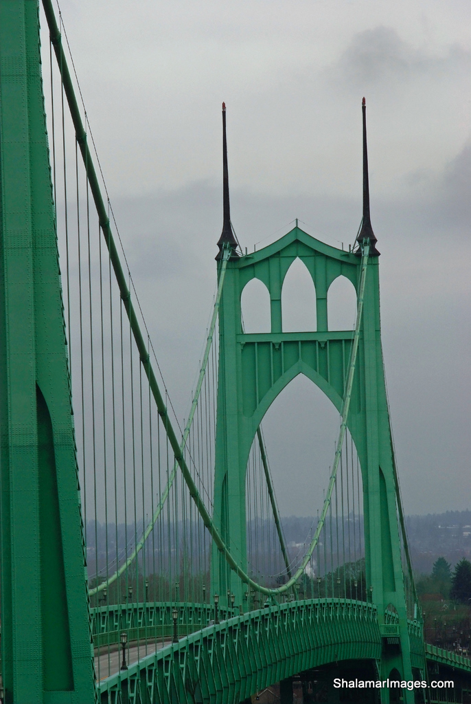 |
| St Johns Bridge |
If you are heading West on Hwy #30 and take the St Johns bridge exit to climb the steep road to the bridge entrance you will see a turnout about ¾ of the way up on you’re left. Park here and proceed West on foot approximately 1000 ft until you come to a series of steep concrete steps that lead to a landing with a hand rail. Continue west a very short distance until you come to a wood footbridge that overlooks the bridge and that is relatively free from blocking trees. This will be your tripod spot.
 |
| Architectural Lines |
You will find many compositions in this area as well.
Sunday, January 24, 2010
Cape kiwanda Photography
 |
| Haystack Rock Sunset |
The compositions are endless the weather is ever changing and the wave action can’t be beat. The reddish sandstone cliffs are beautiful as well.
To top things off the Pelican Brewery is only a stones throw from the parking area. Great food and even better selection local Micro Brew. They serve breakfast lunch and dinner. I highly recommend the restaurant.
Now back to the cape and the photography. If you’re coming from out of town you can stay at the Inn at Cape Kiwanda . This will allow you to chase the sweet light morning and evening. One day is not enough in my opinion to truly capitalize on the possibilities here.
 |
| Unique Formations |
Very near to the cape is Bob Straub State Park where you will have distant views of Haystack Rock and lots of grasses that always make a great foreground element.
Getting there: From Lincoln City, follow U.S. 101 North through the town of Neskowin and follow the signs to Cape kiwanda. From the Portland area take Hwy 22 through Salem then tie into Hwy #18 west. Take a right turn in the town of valley junction onto Hwy #22 Tillamook/ Hebo and follow this winding narrow road until you see a left turn off for Pacific City, you will now be on Hwy #130. Follow this straight into Pacific City..
Just a quick side note about Haystack Rock; yes it’s true there is more than one Monolith off of the Oregon coast with that name, in fact there are three. You will find one haystack rock in the town of Cannon Beach another in Pacific City and the final one is located outside of Bandon on the Southern Oregon Coast.
Wednesday, January 13, 2010
Moulton Falls County park
 |
| Wooden Footbridge At Moultan Falls Park |
 |
| Moultan Falls |
the wooden footbridge you see pictured here is located in the heart of Moulton Falls county park in SW Washington state. Situated along the East Fork of the Lewis River, there are several water features along the drive including Lucia Falls, Moulton Falls and Sunset Falls.
I recommend this venture for hikers and photography buffs, Be advised however that the parking areas are closed this time of year for unknown reasons to me. Parking is very limited on the roadsides due to a lack of a wide shoulder.
Getting There: Drive Sate route #503 north through the town of Battleground and make a right turn on NE Rock Creek Rd just past 319Th. Once you have made you're turn you will follow Lucia Falls Dr. to a signed parking area for Lucia Falls. Next stop will be Moulton falls about 1 mile further, parking will be on the left at the falls. The Footbridge and hiking trails are directly across the street via the upper parking area. If you wish to continue you may visit Sunset falls state park just 7 miles up NE Sunset Falls Dr.
Subscribe to:
Posts (Atom)
