Sunday, January 24, 2010

Cape kiwanda Photography


Haystack Rock Sunset
All I can say is wow! What a photographers dream. I’m talking about The Oregon coastal hot spot of Cape Kiwanda. I have seen so many wonderful dramatic images from this area but personally have never explored the cape before yesterday. Laurie and I drove up to catch the sunset and get the dog out for some exercise. As I started climbing the cape I instantly knew I was in for a real treat photographically speaking.

The compositions are endless the weather is ever changing and the wave action can’t be beat. The reddish sandstone cliffs are beautiful as well.

To top things off the Pelican Brewery is only a stones throw from the parking area. Great food and even better selection local Micro Brew. They serve breakfast lunch and dinner. I highly recommend the restaurant.

Now back to the cape and the photography. If you’re coming from out of town you can stay at the Inn at Cape Kiwanda . This will allow you to chase the sweet light morning and evening. One day is not enough in my opinion to truly capitalize on the possibilities here.
Unique Formations
There are restricted areas that are somewhat cordoned off but most people disregard the warnings and proceed anyway. Be careful near the cliffs but especially watch out for sneaker waves if you’re shooting near the ocean on the north side of the cape.

Very near to the cape is Bob Straub State Park where you will have distant views of Haystack Rock and lots of grasses that always make a great foreground element.


Getting there: From Lincoln City, follow U.S. 101 North through the town of Neskowin and follow the signs to Cape kiwanda. From the Portland area take Hwy 22 through Salem then tie into Hwy #18 west. Take a right turn in the town of valley junction onto Hwy #22 Tillamook/ Hebo and follow this winding narrow road until you see a left turn off for Pacific City, you will now be on Hwy #130. Follow this straight into Pacific City..

Just a quick side note about Haystack Rock; yes it’s true there is more than one Monolith off of the Oregon coast with that name, in fact there are three. You will find one haystack rock in the town of Cannon Beach another in Pacific City and the final one is located outside of Bandon on the Southern Oregon Coast.

Wednesday, January 13, 2010

Moulton Falls County park


Wooden Footbridge At Moultan Falls Park
Moultan Falls
After doing a little research on the web trying to find the whereabouts of a certain bridge that I've seen photographed a few times, I was finally successful.

the wooden footbridge you see pictured here is located in the heart of Moulton Falls county park in SW Washington state. Situated along the East Fork of the Lewis River, there are several water features along the drive including Lucia Falls, Moulton Falls and Sunset Falls.

I recommend this venture for hikers and photography buffs, Be advised however that the parking areas are closed this time of year for unknown reasons to me. Parking is very limited on the roadsides due to a lack of a wide shoulder.


Getting There: Drive Sate route #503 north through the town of Battleground and make a right turn on NE Rock Creek Rd just past 319Th. Once you have made you're turn you will follow Lucia Falls Dr. to a signed parking area for Lucia Falls. Next stop will be Moulton falls about 1 mile further, parking will be on the left at the falls. The Footbridge and hiking trails are directly across the street via the upper parking area. If you wish to continue you may visit Sunset falls state park just 7 miles up NE Sunset Falls Dr.

Thursday, December 10, 2009

HDR Software Reviews

F-14 Tomcat HDR

Are you ready to try something a little different this winter? Does the weather have you home bound or just uninspired photographically. This time of year is when most landscape enthusiasts are able to spend more time on the computer finishing the backlog of shots that were taken in the preceding months.

I currently use HDR(High Dynamic Range) software for finishing landscape images where my cameras sensor can’t pick up the many stops of light in a dynamic scene. Recently however I've begun using HDR simply as a tool to render surreal and sometimes otherworldly images as strictly an independent art form…..Bye the way, it’s also quite fun.

I will introduce you to a few programs out there including freeware, shareware and trial software that you will pay for later. Each program has it’s pro’s and cons and little quirks as well. The program that is the most recognized starts out our review at no (1) Photomatix Pro is a plug-in extension for Adobe products such as Adobe Photoshop Lightroom 2 , Apple Aperture 2.1.1 and Adobe Photoshop CS4. The Pro version can be purchased as a stand-alone program for those using other imaging software. Version 3 is currently out and can be purchased for $99.00 from Amazon.com. I recommend getting the free trial version before laying out the cash.

At no. (2) on our list is called Easy HDR written by Bartłomiej Okonek or (Bartek). I personally purchased this software and use it primarily for my landscapes. You can check out the flickr pool of shots here. Easy HDR by its namesake is very simple to use and provides great online tutorials.
Currently I use a free program called Qtpfsgui it also makes no. (3) on our list. A great program for deep manipulation as seen above with the F-14 Tomcat image.

Here is a great site to see a list of free HDR software
I can highly recommend the following two HDR books...

Sunday, October 25, 2009

Little Zigzag Falls Directions

Little ZigZag Falls

Here’s my take on this little charmer, one of only a few waterfalls on Mt Hood, the little Zigzag Falls are not a disappointment. The very short hike will reward you with the 75-foot drop high volume falls. The Little Zigzag Falls on the West side of Mt. Hood has very easy access.

Getting There: Head East on Hwy #26 after passing the towns of Rhododendron and Zigzag on you’re way towards Govt. Camp and as the road starts a continuous uphill grade start looking at road markers on the left. Approximately 4 miles East of Rhododendron you will turn left on Road #39; a large sign that directs you to the Mt Hood Kiwanis Camp also denotes this road. After turning onto Road #39 drive until the road ends ½ mile past the Kiwanis camp. There is a large turnout and a clear marked trailhead. The falls are a mere 1/3 of a mile upstream.

Other falls to consider while up on the mountain are: Tamanawas Falls located just past Sherwood Campground on Hwy #35 also you may enjoy Sahale Falls accessed just past the Mt Hood Meadows ski area off of Hwy #35.

Saturday, October 3, 2009

Custom White Balance Suggestions


As a landscape photographer you may never have thought about introducing a custom white balance to you’re workflow in the field, but you may wish to try this option after reading further. I’ve always known about the option of custom white balance in my cameras menu, however never gave it much thought. A fellow photographer who shoots primarily outdoor portraits opened my eyes to this option and made me take a second look at the technique.
Most photographers agree that white balance issues are quite correctable in post processing whether shooting RAW or JPEG. Correcting an entire photo is one thing but nailing the white balance in a specific area is quite another. For instance you may wish to have perfect white balance on foreground elements and let the rest of the photo take on characteristics from an unusual colorcast on water elements that add to the visual impact of the scene.
There are several tools that allow one to achieve perfect white balance read from surrounding light specific to a scene. From a simple Grey Card to a fitted white lens cover; one company makes a lens cap that will replace the factory cap and will provide perfect white balance. In my estimation the best tool on the market and not surprisingly the most expensive tool is the ExpoDisc made by Expo Imaging. It is the painstaking way that the ExpoDisc is constructed of high optical grade plastics that provide perfect neutrality and diffuse the light before it hits the image sensor. The results are stark and for me a game changer.

Using the ExpoDisc is quick and simple. Go into the custom menu of you’re DSLR and then into the custom white balance turn it on place the ExpoDisc on the front of you’re lens and depress the shutter release to set the white balance for that scene.

Other tools with great fanfare are the Lastolite Ezybalance collapsible grey and white panels. They are washable and stow easily and will double as a reflector or hood shade.
Also the “ Digital Calibration Targets “ From Photovision Products can be used on the back end providing a perfect white section, 18 % grey in the center for nailing exposure. A black section is also included on the same panel for you’re eyedropper tool in P/S to dial in a true black that may be lacking in you’re composition.

Just because you may not be a portrait photographer don’t be shy about using custom white balance tools for landscape and Macro work. Happy shooting Shawn…

Note: Photo provided by expoimaging.net

Sunday, September 27, 2009

Elowah Falls Info And Directions

Elowah Falls


Took another trip to Elowah Falls Today …trying to capture a full-length shot of the drop. I took “Scout “ our new boxer puppy that is about three months old now and seems to love the trail. Anyway the crowds were low at least in this area, and so by the way was the water level. The low flow of the falls allowed me to climb up the right flank that would otherwise be a misty soggy treacherous and somewhat dangerous climb. As you can see I achieved my goal of photographing the entire falls although I’m not thoroughly happy with the composition. I tried a couple of comps from stream level but nothing really inspired me.

For some reason these falls give me some trouble and present challenges that other falls don’t. At any rate you can expect a different look from these falls every visit and it's such a short hike 1.4 mile R/T from the parking area that many visits may be warranted.

Getting There: Heading I-84 Eastbound take the Ainsworth park exit the proceed further East on Frontage Road approximately 1 ½ miles to the John B. Yeon State park turnout. There’s room for about 15 cars and there are no facilities." Note " You can also access McCord Creek Falls from this parking area.

Saturday, September 12, 2009

Eastern Oregon,Hells Canyon and the Painted Hills


Laurie and I just got back from an Eastern Oregon road trip that encompassed the entire northeast region of the state. It’s hard to believe we traveled over 900 miles and never crossed state lines and really only scratched the surface in terms of exploring Oregon in it’s entirety.
The Painted Hills

The trips conception was certainly based on photographic pursuits as well as seeing areas of Oregon that were new to us. On the short list were of course the Painted hills, Hells Canyon, and the Wallawa Mountains to include Wallawa Lake.


We traveled over Mt Hood through Maupin down into Shaniko, Fossil and finally reached the town of Clarno. The first of three visitor areas that make up the John Day Fossil beds National Monument start in Clarno. There is little to see here except for some ancient rock formations that were formed 55 million years ago
. Just three miles east of Mitchell Oregon we found the Painted Hills Unit. These are spectacular and quite stunning to see first hand. A photographer’s paradises indeed as you catch the first glimpse of color in the hills. However it’s not just the color that makes this place so special; but also the perceived texture of the formations that give it that otherworldly feel. The formations look like velvet but are actually made up of hard clay, Siltstone and Shale.
Painted Patterns

Approximately 1-hour east near John day are the Sheep Rock Unit and more fossil beds. This area was a bit of a disappointment. We were to late to enter the Thomas Condon Paleontology Center, which houses all of the regions Fossil collections. Also the formations were jagged and a bluish green in color. If we had more time I would have liked to take in a couple of the nearby hiking options to explore further.


We spent the first night at the Best Western in John Day knowing full well we had a huge day ahead of us in the morning. After several hours of wandering through vast uninhabited regions of the northeast we stopped in Baker City to refuel ourselves as well as the car. The next objective was to head into the Hells Canyon region of Oregon to catch a glimpse of the Mighty Snake River. It turns out that the wild Snake River is considerably north and down stream of the Hells Canyon Dam. We never did see any beautiful scenery of the Snake River and decided to cut our losses and take the only road over towards Joseph and Wallowa Lake. Yes it is a 64-mile wild ride of twists and turns that takes you past the Hells Canyon Overlook. It is quite a vista and deep gorge and yet the Snake remains elusive even here.

Painted Detail
Hells Canyon Overlook
When we finally reached Joseph we were somewhat weary travelers at this point and decided to book a room only minutes from the lake. Stayed in a old but quaint motel called the Indian Lodge Motel. New mattresses and fire hydrant like water pressure in the showers were a couple of nice attributes. The town of Joseph is very nice and is bolstered by a huge art community that has donated many works to the city, which are displayed along the streets. Apparently there are three bronze foundries in town as well. The town takes on a wonderful vacation feel in the evening hours as many of the business are creatively lit which ads to the warmth of the town. We took an evening stroll after enjoying a fireside outdoor meal at the Embers Brewhouse.
Wallowa Lake At Dawn

I awoke early, pre dawn in fact to photograph Wallowa Lake; however that magic moment never materialized and I was disappointed with all of the images. The sweet light doesn’t always happen especially on a cloudless Eastern Oregon morning.

Anthony Lakes

The next day took us through Tollgate Oregon and up and over the Blue Mountains where we visited the Anthony Lakes area.
We then came through Pendleton and linked up with I-84. It's a 200-mile trip through the Gorge to home so we stopped off in the Dalles for a Mexican dinner at El Mirador.
Great trip as always and I thank Laurie for all the safe driving and companionship.

Sunday, August 2, 2009

Oneonta Gorge Adventure Awaits You !!


Oneonta Gorge


Have you wanted to go on a really cool little adventure? Well I have the answer and it may come as a surprise how relatively easy it is and within such a close proximity to the Portland area. I'm talking about Oneonta Gorge located just east of Multnomah Falls on the Historic Columbia River Highway.

The adventure part comes in when you're hiking trail is a stream and you must negotiate a huge log jam; other than that it's a piece of cake in terms of outdoor photography outings. You see over the course of a couple of extreme winters and subsequent flooding huge amount of deadfall and lumber have piled up in the mouth of Oneonta Gorge. Once the logs have been crossed it's an extremely easy stroll through the creek less than ½ mile to the Lower Oneonta Gorge waterfall.
Oneonta's Narrow Gorge

The water this time of year was extremely comfortable and the deepest pool went up to my waist. I'm 6' 3" and so I may not recommend this hike for smaller children. I chose to wear my Hodgman Wading boots with the felt sole, worked like a charm. Get there early to avoid crowds if you can. I arrived at 8 am and had the Gorge to myself, any earlier and lack of light would be an issue. You also may be wondering if there are dry spots to set you're gear down and set up shot and yes there are plenty of dry areas that are exposed this time of year.
Oneonta Falls

Getting There: Coming from Portland take the Bridal Veil Exit off of I-84 then proceed East passing Multonmah falls by approximately 1 mile. The parking area is well marked on the right side of the road and is denoted by a large sign reading Oneonta Gorge as well as a large wood pedestrian tunnel.

Happy adventures, Shawn…

Sunday, July 26, 2009

Heceta Head Lighthouse And The Legend Of The Lady In Grey


Most of the Family and I just got back from a mini trip to the central Oregon Coast. Florence to be exact where we rode Quads at
Winchester Bay in the heart of dune country just south of Reedsport Oregon. I highly recommend this activity. If you are a first timer and want to get an idea of the sport there are many rental options in the area. I recommend Dune Country ATV rentals.

One of the main attractions of the trips for me was to visit and photograph the nearby lighthouses. The Umpqua lighthouse is located virtually next door to the previously mentioned Dune Country and in the heart of Discovery Bay. The Lighthouse itself sits amongst the Coastguard barracks and housing making photography very uninspiring. The lighthouse is well kept and has been freshly painted. The only good vantage point for photography is from out in the dunes area looking back at the lighthouse. You may be able to eliminate most of the distracting elements from this vantage point.
Heceta Head Lighthouse

Next we set off approximately 1-hour north on the #101 to visit the Heceta Head Lighthouse. Just prior to reaching the parking area you will be rewarded with a spectacular view of the lighthouse from a roadside viewpoint. Once inside the parking area there is a self-pay area that you will need to purchase a $3.00 parking permit from. There are nice well maintained trails that take you right up to the lighthouse where guided tours are available for those that are inclined to walk inside and hear a little history about the area and the adjacent
haunted lightkeepers house. The legend of the Gray Lady.
As far as photography goes, there are many compositions to choose from and as a matter of fact a trail will lead you directly behind the lighthouse so you may get this vantage point.

Ideally the best scenario is to sit patiently behind the lighthouse looking west and wait for that incredible sunset and capturing the glow of the Fresnel lens as it makes it’s revolutions. This would require some planning and walking out in the dark of night.

I wish to make a trip back to do just that and in addition would spend several hours at the
Cape Perpetua Scenic Area. Along with “ Cooks Chasm “ and “ Spouting Horn “ the park offers so much photographically in terms of big waves and lava formations. It should be on the short list of every landscape photographer.

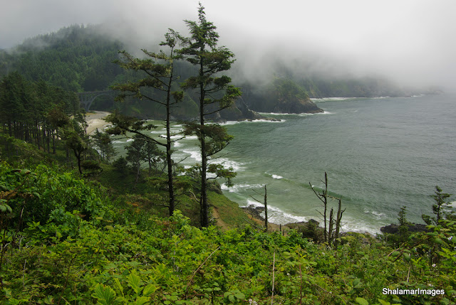
Heceta Coastline with Cape Creek Bridge

Happy shooting. Shawn….

Tuesday, July 21, 2009

Lewis River Falls Hike


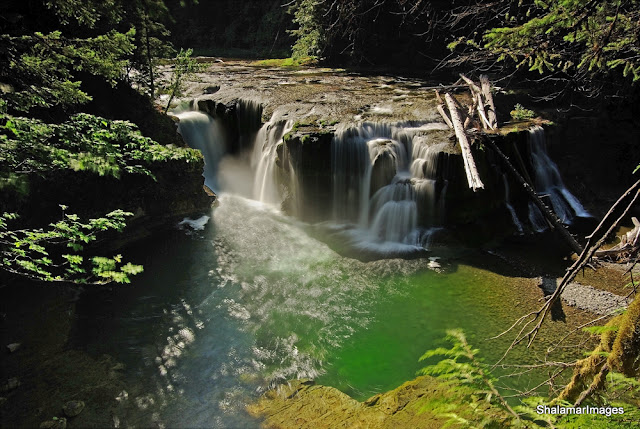
Lower Lewis River falls
The Northwest landscape never ceases to amaze me, as each subsequent trip seems to be more picturesque than the next. Laurie and I recently got back from another great photo/hiking excursion. Our original intentions were to access Lava Canyon via rd 83 on the south side of Mt St Helens, which I believe, is now open after some major storm repair. However according to the US Forest Service web site the actual lava canyon trail is now under going several weeks of renovation as of July 2nd. Luckily I usually have an alternate plan and we ended up at Lewis River campground. We arrived at the campgrounds around 9am with perfect light hitting the lower falls that were located only ¼ mile from our car. Had a wonderful time photographing the falls from many different comps and hesitantly agreed we should continue upstream to witness the middle and upper falls. All in all we hike approximately 7 miles through some beautiful riverside terrain. I highly recommend this hike for everyone in the family.

Getting there: From I-5 drive to the town of Woodland Washington and take exit #21. Follow the signs for Mt St Helens and Lava Canyon via State route #503. Drive approximately 46 miles until you reach the small town of Cougar. Continue straight on spur rd #90. Just past the Pine creek information station turn right on what continues to be rd #90. Drive an additional 14 miles until you reach the Lower Lewis river recreation area and campground. Proceed to the day area and park near on of the restrooms Go towards the raging river and follow signs to the lower falls viewing area. The profiled hike will follow the river upstream for 2 ½ miles reaching the upper Lewis River Falls.

Coming from I-84 take the Hood River toll bridge through White Salmon then continue north passing through Husum, BZ Corner and finally Trout Lake where you can tie into forest rd#90. Additionally coming from the West Gorge you can travel through the town of Carson and up the Wind River .


Some additional photos from the trip are found here.

Happy Hiking, Shawn…
All Content © ShalamarImages.com
and Shawn Martin
Copyrights vigorously enforced